| CPC G01V 1/368 (2013.01) [G01V 2210/1425 (2013.01); G01V 2210/51 (2013.01); G01V 2210/677 (2013.01)] | 7 Claims |
|
1. A method comprising:
iteratively performing, using a dual-sensor device, onshore separated wave-field imaging, wherein the dual-sensor device is disposed on an onshore surface and comprises:
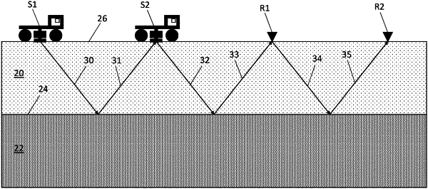
a plurality of seismic sources including a first seismic source and a second seismic source located adjacent to the first seismic source, the plurality of seismic sources positioned at a first location on the onshore surface;
a plurality of receiving sensors including a first receiving sensor and a second receiving sensor located adjacent to the first receiving sensor, the plurality of receiving sensors positioned at a second location on the onshore surface, wherein:
the first location is dissimilar to the second location;
the plurality of seismic sources is configured to issue one or more waves; and
the plurality of receiving sensors is configured to receive one or more waves issued by the plurality of seismic sources, wherein:
a first ray path is defined from the second seismic source to the first receiving sensor by one or more waves issued from the second seismic source to the first receiving sensor, the first ray path defining a primary reflection;
a second ray path is defined from the second seismic source to the second receiving sensor, the second ray path being a multiple of the primary reflection and having a bounce at a location of the first receiving sensor on the onshore surface;
collecting data representative of a boundary beneath the onshore surface using the plurality of seismic sources and the plurality of receiving sensors;
performing, by a processor configured to execute instructions encoded within computer readable media accessible to the processor, onshore separated wave field imaging on the data, wherein performing onshore separated wave field imaging comprises:
calculating, by the processor, up-going and down-going fields from the data for the first ray path;
generating, by the processor, an image that is representative of the boundary and a free-surface reflection by applying a separated wave-field migration algorithm with a deconvolution imaging condition to the calculated up-going and down-going fields, the deconvolution imaging condition comprising:
transforming, by the processor, the second seismic source into a virtual receiver based on deconvolution of the second ray path by the first ray path; and
transforming, by the processor, the first receiving sensor into a virtual source based on deconvolution of the second ray path by the first ray path;
determining, by the processor, whether the image is distorted by a distortion caused by a free-surface reflection coefficient associated with the multiple; and
subtracting, by the processor, the distortion from the image by evaluating the free-surface reflection statistically using the data and through applying the separated wave-field migration algorithm.
|