| CPC H04N 23/698 (2023.01) [G06T 3/4038 (2013.01); H04N 1/32128 (2013.01); H04N 2101/00 (2013.01); H04N 2201/3253 (2013.01)] | 7 Claims |
|
1. A system for producing panoramic image content, comprising:
a user device generating first panoramic image data including a first panoramic image and imaging information, and including a first tag data set having new tag data for at least one object, including a first object, deployed on a first panoramic image, the user device including a display; and
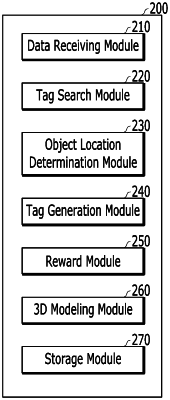
a panoramic image server including a memory having instructions executed by a processor causing the processor to perform a method of:
receiving the first panoramic image data and the first tag data set from the user device;
searching for at least one pre-stored tag data, with respect to the first object, existing in a predetermined region, based on the imaging information of the first panoramic image data;
generating united tag data by calculating a location of the first object, based on the pre-stored tag data searched for with respect to the first object and the new tag data; and
adding tag information of the first object to the panoramic image data based on the united tag data, wherein:
the pre-stored tag data and the new tag data comprise imaging origin information SI on a location in which the first panoramic image is shot and object location information on the first object,
an extension line is formed to extend from an end of a connection line that connects an imaging origin SP, based on one piece of the imaging origin information SI, to a first object location, based on one piece of the first object location information,
an object location determination module calculates the location of the first object by an average value of intersection points among a plurality of extension lines being formed, based on at least one piece of the pre-stored tag data and a location information set of the new tag data, and determines a number of location information sets of the pre-stored tag data searched for with respect to the first object,
the imaging origin information SI and the first object location information comprise a first parameter, a second parameter, and a third parameter for the first object location,
the object location determination module generates the united tag data using the average value of the intersection points of the extension lines being formed with respect to the first object, based on the first to third parameters of the imaging origin information SI and based on the first object location information in case that there are two or more location information sets of the pre-stored tag data searched for by the panoramic image server with respect to the first object, and wherein
the object location determination module generates the united tag data using the average value of the intersection points of the extension lines being formed with respect to the first object, based on the first and second parameters of the imaging origin information SI and based on the first object location information in case that there is one location information set of the pre-stored tag data searched for by the panoramic image server with respect to the first object.
|