| CPC G06F 16/29 (2019.01) [G06F 16/248 (2019.01); G06F 16/2458 (2019.01); G06F 16/24573 (2019.01); G06F 16/25 (2019.01)] | 19 Claims |
|
1. A method for conflating data sources, the method comprising:
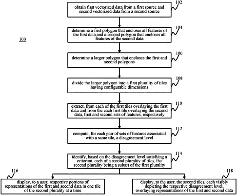
obtaining first data from a first source and second data from a second source, wherein the first and second data cover at least a portion of a same spatial region, and wherein each of the first and second data comprises an aerial or satellite image that is converted to a vectorized list of roads;
determining a first polygon that encloses the roads of the first data of the first source;
determining a second polygon that encloses the roads of the second data of the second source, wherein the first and second polygons are of different sizes;
determining a polygon that simultaneously encloses both of the first and second polygons;
dividing the larger polygon into a first plurality of tiles, each belonging to a different portion;
overlaying each of the first plurality of tiles over a corresponding portion of each of the first polygon and the second polygon;
extracting, for a portion of the first data and a portion of the second overlayed by a respective tile of the first plurality of tiles, a first and second set of features, respectively;
comparing the first set of features extracted from each of the portions of the first data with the second set of features extracted from the corresponding portion of the second data;
computing, for each of the comparisons, a disagreement level;
selecting, from the first plurality of tiles based on at least one of the computed disagreement levels satisfying a set of criteria, a second set of tiles;
outputting each of the second set of tiles overlaying a representation of a respective portion of the first data and/or a representation of a respective portion of the second data; and
iteratively displaying, to a user in a prioritization order according to the disagreement levels, the each second tile.
|