| CPC G06V 20/53 (2022.01) [G16Y 40/35 (2020.01); H04L 67/12 (2013.01)] | 6 Claims |
|
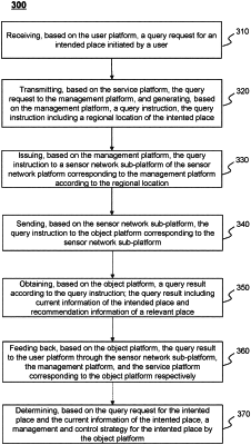
1. A method for counting and regulating pedestrian volume in a public place of a smart city, which is realized based on an Internet of Things system for counting and regulating the pedestrian volume, wherein the Internet of Things system for counting and regulating the pedestrian volume comprises a user platform, a service platform, a management platform, a sensor network platform, and an object platform, and the method comprises:
receiving, based on the user platform, a query request for an intended place initiated by a user;
transmitting, based on the service platform, the query request to the management platform, and generating, based on the management platform, a query instruction, wherein the query instruction includes a regional location of the intended place;
issuing, based on the management platform, the query instruction to a sensor network sub-platform of the sensor network platform corresponding to the management platform according to the regional location, wherein the sensor network platform performs data storage, data processing, and/or data transmission for data of different object platforms by using different sensor network sub-platforms, and the different sensor network sub-platforms correspond to different regional locations;
sending, based on the sensor network sub-platform, the query instruction to the object platform corresponding to the sensor network sub-platform;
obtaining, based on the object platform, a query result according to the query instruction, wherein the query result includes current information of the intended place and recommendation information of a relevant place; and
feeding back, based on the object platform, the query result to the user platform through the sensor network sub-platform, the management platform, and the service platform corresponding to the object platform respectively, wherein
the obtaining, based on the object platform, a query result according to the query instruction includes:
obtaining information of the intended place and the relevant place in a regional place map and generating the query result based on the object platform according to the query request, wherein
different nodes in the regional place map represent different places, attributes of the nodes in the regional place map include place real-time information and place basic information, the place real-time information includes at least one of a current pedestrian volume, or current management and control information, and the place basic information includes at least one of a place type, or a place location; and
an edge in the regional place map is configured to connect two nodes, a mutual relationship of which meets a preset condition, the preset condition is that a place type difference of places corresponding to two connected nodes is smaller than a preset difference value, or a spatial distance of the places corresponding to the two connected nodes is less than a distance threshold, wherein
determining the relevant place includes:
dividing, based on a preset algorithm, the regional place map into several sub-maps, wherein the preset algorithm includes:
designating n nodes as benchmark nodes respectively and determining n edge betweenness centrality values of each edge of all the edges;
for each node of the n nodes,
designating the node as the benchmark node and determining a shortest path from the benchmark node to other nodes; and
calculating the edge betweenness centrality values of all the edges in the regional place map based on the shortest path;
obtaining a total value of edge betweenness centrality of each edge by summing the n edge betweenness centrality values of each edge, wherein the total value of edge betweenness centrality is obtained by weighed sum of the n edge betweenness centrality values, and determining a second weight used for the weighted sum based on a user request includes:
determining a difference in pedestrian volume between two nodes corresponding to each edge as the second weight, the difference being negatively correlated with the second weight;
obtaining a score value of edge betweenness centrality of each edge based on the total value of the edge betweenness centrality of each edge; and
dividing the regional place map based on the score value of edge betweenness centrality score of each edge;
determining, based on the query request, a target sub-map from the several sub-maps; and
determining, based on the target sub-map, a recommendation node, and determining a place corresponding to the recommendation node as the relevant place, wherein
the recommendation information of the relevant place includes a recommendation index of the relevant place, and determining the recommendation index of the relevant place includes:
determining the recommendation index by processing the current pedestrian volume information of each node and a relationship between each node and the intended place in the target sub-map based on a recommendation model, wherein for each node, the relationship between each node and the intended place includes: an edge weight and the score value of edge betweenness centrality of each edge connecting the corresponding node and the node corresponding to the intended place in the target sub-map.
|