| CPC E21B 44/00 (2013.01) [E21B 2200/20 (2020.05); E21B 2200/22 (2020.05)] | 20 Claims |
|
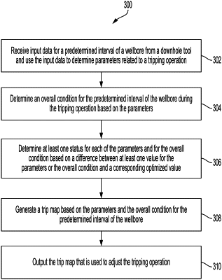
10. A method comprising:
receiving, by a processing device, input data for a predetermined interval of a wellbore from a downhole tool deployable in the wellbore, the input data usable to determine a plurality of parameters relating to a tripping operation with respect to the wellbore;
determining, by the processing device, an overall condition for the predetermined interval of the wellbore during the tripping operation based on the plurality of parameters;
determining, by the processing device, at least one status for each parameter of the plurality of parameters and for the overall condition based on a difference between at least one value for the plurality of parameters or the overall condition and a corresponding optimized value;
generating, by the processing device, a trip map based on the plurality of parameters and the overall condition for the predetermined interval of the wellbore, the trip map being a visual representation of the plurality of parameters and the overall condition, the trip map comprising:
a background shape including the plurality of parameters and the overall condition positioned angularly around the background shape;
a polygon positioned on the background shape, the polygon including a plurality of corners, each corner of the plurality of corners corresponding to the overall condition or to different parameters of the plurality of parameters, each corner positioned at different radial positions of the background shape based on the at least one status; and
outputting, by a user interface, the trip map that is usable to adjust the tripping operation.
|